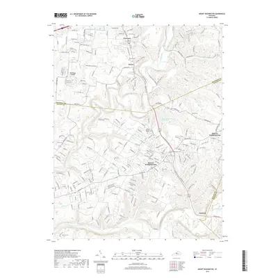
2019 Map of Mount Washington
USGS Topo · Published 2019About this map
Mount Washington and its surrounding countryside in 2019 exhibit a complex pattern of modern suburban expansion layered over an older agricultural and burial landscape. Numerous family and community burial grounds, such as Saint Francis Cem, Showalter Cem, and the Markwell Cem near the eastern boundary, provide essential touchstones for genealogical research in this part of Jefferson and Bullitt counties. The hydrological network of the Salt River and its many tributaries like Floyds Fork and Whites Run historically dictated the placement of early settlements and roads. Modern recreational additions like the Louisville Loop and Paw Paw Trail now wind through the drainage basins of Broad Run and Turkey Run, while established neighborhoods like Heritage Creek and Fairmount continue to grow along major corridors like Bardstown Rd.
Find a feature on this map
203 named features on this map. Tap any name to fly to it.
Don’t see what you’re looking for? This feature index may not catch every label — zoom into the map to look around manually.
Map Details
Editions of this 2019 Mount Washington Map
This is the sole edition of this map. No revisions or reprints were ever made.
Other maps of this area

1907 · Louisville
USGS Topo · 1:62,500

1929 · Taylorsville
USGS Topo · 1:62,500

1949 · Shepherdsville
USGS Topo · 1:24,000

1949 · Samuels
USGS Topo · 1:24,000

1949 · Shepherdsville
USGS Topo · 1:62,500
1951 · Louisville East
USGS Topo · 1:24,000

1951 · Jeffersontown
USGS Topo · 1:24,000

1951 · Fisherville
USGS Topo · 1:24,000

1951 · Waterford
USGS Topo · 1:24,000
1951 · Brooks
USGS Topo · 1:24,000