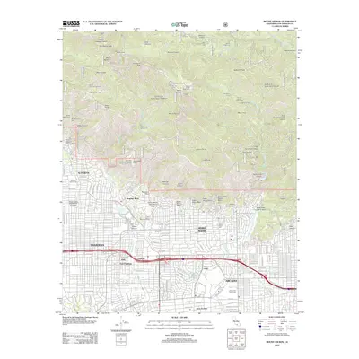
2012 Map of Mount Wilson
USGS Topo · Published 2012About this map
Mount Wilson Observatory stands as the crowning landmark of this San Gabriel Mountain landscape, overlooking a dense network of suburban development and canyon trails. The map highlights the sharp transition between the residential grids of Pasadena, Altadena, and Arcadia and the steep wilderness of the Angeles National Forest. This 2012 survey illustrates the critical infrastructure managing the region's hydrology, including the Eaton Canyon Reservoir and an extensive series of debris basins such as the Sierra Madre Debris Basin and Santa Anita Debris Basin. Historic recreation sites and summits like Echo Mountain, Mount Lowe, and Inspiration Point are documented alongside local institutions like William Carey International University. The presence of the Sierra Madre Cem and various golf courses provides valuable points of reference for genealogists and local historians tracking the modern layout of these established Los Angeles County communities.
Find a feature on this map
162 named features on this map. Tap any name to fly to it.
Don’t see what you’re looking for? This feature index may not catch every label — zoom into the map to look around manually.
Map Details
Editions of this 2012 Mount Wilson Map
This is the sole edition of this map. No revisions or reprints were ever made.
Other maps of this area

1894 · Los Angeles
USGS Topo · 1:62,500

1894 · Pomona
USGS Topo · 1:62,500

1896 · Pasadena
USGS Topo · 1:62,500

1897 · Pomona
USGS Topo · 1:62,500

1898 · Pomona
USGS Topo · 1:62,500

1900 · Pasadena
USGS Topo · 1:62,500

1900 · Tujunga
USGS Topo · 1:62,500

1900 · Los Angeles
USGS Topo · 1:62,500

1901 · Southern California Sheet No. 1
USGS Topo · 1:250,000

1903 · Rock Creek
USGS Topo · 1:62,500