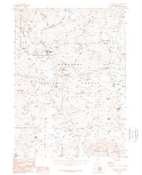
1986 Map of Mountain City
USGS Topo · Published 1987About this map
Mountain City and the nearby settlement of Patsville serve as the primary hubs in this remote Elko County landscape, where the Owyhee River carves through the high terrain of northeastern Nevada. The region’s deep ties to the mining industry are evident in the dense concentration of extraction sites, including the Golden Ensign Mine, the California Hill Prospect, and numerous adits and shafts scattered across the Huber Hills. This 1980s-era data highlights a landscape transitioning between federal land management and tribal sovereignty, with the Duck Valley Indian Reservation bordering the north and the Humboldt National Forest spanning much of the southern reach.
Find a feature on this map
58 named features on this map. Tap any name to fly to it.
Don’t see what you’re looking for? This feature index may not catch every label — zoom into the map to look around manually.
Map Details
Editions of this 1986 Mountain City Map
This is the sole edition of this map. No revisions or reprints were ever made.
Other maps of this area

1936 · Mountain City
USGS Topo · 1:62,500

1939 · Owyhee
USGS Topo · 1:62,500

1940 · Mountain City
USGS Topo · 1:62,500

1942 · Owyhee
USGS Topo · 1:62,500

1955 · McDermitt
USGS Topo · 1:250,000

1955 · Wells
USGS Topo · 1:250,000

1956 · Bull Run
USGS Topo · 1:62,500

1956 · Wild Horse
USGS Topo · 1:62,500

1958 · Wells
USGS Topo · 1:250,000

1959 · McDermitt
USGS Topo · 1:250,000