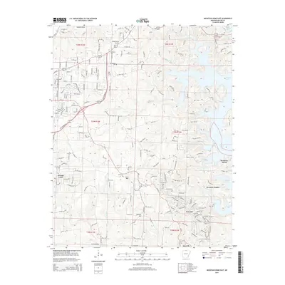
2014 Map of Mountain Home East
USGS Topo · Published 2014About this map
Norfork Lake defines the eastern edge of this Ozark landscape, where the waters of the North Fork River meet the rugged drainages of Panther Creek and Fall Creek. The terrain is marked by distinctive local summits like Birdsong Mountain and Heart Bald, as well as numerous hollows including Goodall Hollow and Camp Spring Hollow. This 2014 survey documents the expanding residential patterns around Mountain Home, with established communities like Briarcliff and Salesville situated among the winding routes of Ar-5 and Ar-341. Genealogists will find a cluster of burial sites concentrated in the western and central portions of the sheet, including E Oakland Cemetery, Old Oakland Cemetery, and Heart Cemetery. Historic transport corridors like Old Military Road and the Sheid Hopper Bypass illustrate how modern infrastructure overlays the older path network of the region.
Find a feature on this map
49 named features on this map. Tap any name to fly to it.
Don’t see what you’re looking for? This feature index may not catch every label — zoom into the map to look around manually.
Map Details
Editions of this 2014 Mountain Home East Map
This is the sole edition of this map. No revisions or reprints were ever made.
Other maps of this area

1890 · Mountain Home
USGS Topo · 1:125,000

1891 · Mountain Home
USGS Topo · 1:125,000

1894 · Mountain Home
USGS Topo · 1:125,000

1945 · Harrison
USGS Topo · 1:250,000

1949 · Harrison
USGS Topo · 1:250,000

1954 · Harrison
USGS Topo · 1:250,000

1958 · Harrison
USGS Topo · 1:250,000

1964 · Harrison
USGS Topo · 1:250,000
1964 · Norfork Dam South
USGS Topo · 1:24,000
1965 · Clarkridge
USGS Topo · 1:24,000