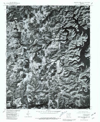
1979 Map of Mountain Home East
USGS Topo · Published 1981About this map
Mountain Home and the western reaches of Norfork Lake dominate this aerial orthophotoquad, which overlays land lines from a 1966 topographic survey onto 1979 imagery. The map reveals the relationship between the growing residential patterns of the town and the deeply recessed, dendritic shoreline of the reservoir to the east. By merging photographic detail with cadastral data, the survey highlights how the Ozark landscape influenced local development, with clearings and roads following the ridgelines and plateaus. This specific edition, produced in cooperation with the Soil Conservation Service, offers a unique visual record of land use and timber cover in Baxter County during the late 1970s.
Find a feature on this map
2 named features on this map. Tap any name to fly to it.
Don’t see what you’re looking for? This feature index may not catch every label — zoom into the map to look around manually.
Map Details
Editions of this 1979 Mountain Home East Map
This is the sole edition of this map. No revisions or reprints were ever made.
Other maps of this area

1890 · Mountain Home
USGS Topo · 1:125,000

1891 · Mountain Home
USGS Topo · 1:125,000

1894 · Mountain Home
USGS Topo · 1:125,000

1945 · Harrison
USGS Topo · 1:250,000

1949 · Harrison
USGS Topo · 1:250,000

1954 · Harrison
USGS Topo · 1:250,000

1958 · Harrison
USGS Topo · 1:250,000

1964 · Harrison
USGS Topo · 1:250,000
1964 · Norfork Dam South
USGS Topo · 1:24,000
1965 · Clarkridge
USGS Topo · 1:24,000