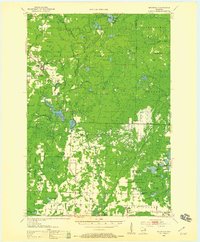
1952 Map of Mountain
USGS Topo · Published 1959About this map
The Oconto River and its varied branches define this 1950s landscape, where the Nicolet National Forest meets the developed farmsteads of central Oconto County. The Chicago and North Western railway cuts a north-south line through the timberlands, connecting the established community of Suring with northern outposts like Mountain and Bonita. Recreation is central to the area's identity, evidenced by the large Boy Scout Camp near Bear Paw Lake and the prominent Mountain Lookout Tower watching over the forested tracts.
Find a feature on this map
75 named features on this map. Tap any name to fly to it.
Don’t see what you’re looking for? This feature index may not catch every label — zoom into the map to look around manually.
Map Details
Editions of this 1952 Mountain Map
2 editions found

Other maps of this area

1940 · Thunder Mtn.
USGS Topo · 1:48,000

1940 · Athelstane
USGS Topo · 1:48,000

1941 · Coleman
USGS Topo · 1:48,000

1942 · Athelstane
USGS Topo · 1:48,000

1942 · Coleman
USGS Topo · 1:48,000

1942 · Breed
USGS Topo · 1:48,000

1942 · Wabeno
USGS Topo · 1:48,000

1950 · Wabeno
USGS Topo · 1:48,000

1950 · Coleman
USGS Topo · 1:48,000

1951 · Wabeno
USGS Topo · 1:48,000