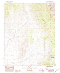
1984 Map of Mountain Springs
USGS Topo · Published 1984About this map
The Spring Mountains dominate this high-desert landscape, where the historical Old Spanish Trail cuts across the southern portion of the quadrangle. The settlement of Mountain Springs sits near the Mountain Springs Summit, marking a critical pass through the range. This area is defined by its vital water sources in an otherwise arid environment, with numerous named points such as Mule Spring, Rainbow Spring, and Bootleg Spring scattered across the complex topography. To the east, the Red Rock Canyon Recreation Lands begin to reveal the dramatic geology of the Red Rock Canyon Recreation Lands Bluffs. The drainage patterns of Lovell Canyon and Lovell Wash illustrate the natural corridors used for travel and seasonal water flow, while the presence of Double Wood Pole Transmission Lines indicates the modern infrastructure threading through these ancient routes.
Find a feature on this map
18 named features on this map. Tap any name to fly to it.
Don’t see what you’re looking for? This feature index may not catch every label — zoom into the map to look around manually.
Map Details
Editions of this 1984 Mountain Springs Map
2 editions found
Other maps of this area

1907 · Las Vegas
USGS Topo · 1:250,000

1908 · Las Vegas
USGS Topo · 1:250,000

1910 · Ivanpah
USGS Topo · 1:250,000

1912 · Ivanpah
USGS Topo · 1:250,000

1942 · Ivanpah
USGS Topo · 1:250,000

1947 · Kingman
USGS Topo · 1:250,000

1948 · Kingman
USGS Topo · 1:250,000

1952 · Blue Diamond
USGS Topo · 1:62,500

1954 · Las Vegas
USGS Topo · 1:250,000

1954 · Kingman
USGS Topo · 1:250,000