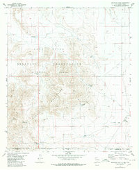
1980 Map of Mountain Tank
USGS Topo · Published 1980About this map
The Hueco Mountains dominate this arid landscape along the border of Otero County, New Mexico, and Hudspeth County, Texas. Much of the terrain is occupied by the Fort Bliss Military Reservation (Mcgregor Range), highlighting the significant military footprint in the high desert during the late 1970s. This survey records a network of critical water resources essential for both ranching and military operations, including Fisher Tank, Mountain Tank, and Wallbridge Tank.
Find a feature on this map
19 named features on this map. Tap any name to fly to it.
Don’t see what you’re looking for? This feature index may not catch every label — zoom into the map to look around manually.
Map Details
Editions of this 1980 Mountain Tank Map
This is the sole edition of this map. No revisions or reprints were ever made.
Other maps of this area

1896 · El Paso
USGS Topo · 1:125,000

1903 · Cerro Alto
USGS Topo · 1:125,000

1908 · El Paso
USGS Topo · 1:125,000

1939 · Heuco Tanks
USGS Topo · 1:62,500

1940 · Heuco Tanks
USGS Topo · 1:62,500

1940 · Bassett Lake
USGS Topo · 1:62,500

1941 · Heuco Mountains
USGS Topo · 1:62,500

1941 · Desert
USGS Topo · 1:62,500

1943 · Desert
USGS Topo · 1:62,500

1943 · Heuco Mountains
USGS Topo · 1:62,500