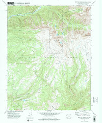
1973 Map of Mountain View Crest
USGS Topo · Published 1976About this map
Needleton sits at the northern edge of this high-altitude landscape, where the Animas River cuts a deep path through the San Juan National Forest. The 1973 survey details a topography defined by significant elevation changes, from the alpine basins of New York Basin to the prominent heights of Mountain View Crest and Mount Kennedy. Transport in this era was dominated by a network of footpaths rather than roads, including the Rio Grande Western Trail and the Needle Creek Trail. Historical activity is evidenced by scattered Prospects on the eastern slopes and family-named landmarks like Henderson Lake. The drainage patterns are complex, with waters flowing from high-altitude features like Webb Lake and Emerald Lake toward the Florida River valley in the south, illustrating the transition from rocky peaks to the meadowed reaches of Big Bear Park and Lower Park.
Find a feature on this map
38 named features on this map. Tap any name to fly to it.
Don’t see what you’re looking for? This feature index may not catch every label — zoom into the map to look around manually.
Map Details
Editions of this 1973 Mountain View Crest Map
This is the sole edition of this map. No revisions or reprints were ever made.
Other maps of this area

1898 · Durango
USGS Topo · 1:62,500

1898 · Engineer Mountain
USGS Topo · 1:62,500

1900 · Engineer Mountain
USGS Topo · 1:62,500

1900 · Needle Mountains
USGS Topo · 1:62,500

1902 · Needle Mountains
USGS Topo · 1:62,500

1907 · Durango
USGS Topo · 1:62,500

1908 · Engineer Mountain
USGS Topo · 1:62,500

1908 · Ignacio
USGS Topo · 1:125,000

1908 · Durango
USGS Topo · 1:62,500

1924 · Ignacio
USGS Topo · 1:125,000