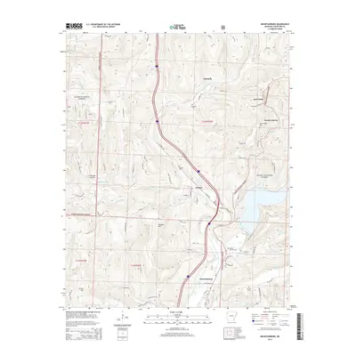
2014 Map of Mountainburg
USGS Topo · Published 2014About this map
Mountainburg and the town of Chester anchor this 2014 survey of the southern Boston Mountains, where the deep drainage of Clear Cr cuts through the high plateaus of the Ozark National Forest. The landscape is defined by its verticality, with local summits like Cartwright Mtn and Locust Mtn rising above Norman Hollow and Meadow Mtn. The map reveals a cluster of settlements and family-named landmarks along the transport corridor of US Highway 71, including Schaberg and the scenic overlook at Artist Point. Genealogists will find value in the precise locations of several burial sites, such as Basham Memorial Cem, Hillcrest Cem, and the Schaberg Cem. To the southeast, the waters of Lake Fort Smith push into the hills, fed by numerous seasonal branches like Warloop Cr and McCaslin Br.
Find a feature on this map
77 named features on this map. Tap any name to fly to it.
Don’t see what you’re looking for? This feature index may not catch every label — zoom into the map to look around manually.
Map Details
Editions of this 2014 Mountainburg Map
This is the sole edition of this map. No revisions or reprints were ever made.
Other maps of this area

1898 · Winslow #4
USGS Topo · 1:62,500

1898 · Winslow #3
USGS Topo · 1:62,500

1898 · Winslow
USGS Topo · 1:125,000

1901 · Winslow
USGS Topo · 1:125,000

1946 · Fort Smith
USGS Topo · 1:250,000

1965 · Fort Smith
USGS Topo · 1:250,000

1967 · Fort Smith
USGS Topo · 1:250,000
1969 · Mountainburg SW
USGS Topo · 1:24,000
1969 · Fern
USGS Topo · 1:24,000
1969 · Rudy
USGS Topo · 1:24,000