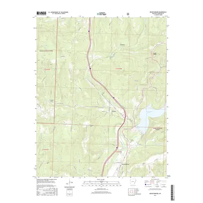
2017 Map of Mountainburg
USGS Topo · Published 2017About this map
The Boston Mountains define the high-relief landscape of this Crawford County region, where the town of Mountainburg sits along the southern edge of the Ozark National Forest. The topography is shaped by deeply incised drainages like Frog Bayou, which feeds into the prominent Lake Fort Smith in the east. This 2017 survey details the transit corridor that follows these natural valleys, including the path of the railroad and Interstate 49 as they wind north through the small settlements of Chester and Schaberg. Local history is anchored by several rural burial grounds, including Basham Memorial Cem and Hillcrest Cem, while landmarks such as Artist Point and Cartwright Mtn provide significant vertical markers in the heavily forested terrain.
Find a feature on this map
63 named features on this map. Tap any name to fly to it.
Don’t see what you’re looking for? This feature index may not catch every label — zoom into the map to look around manually.
Map Details
Editions of this 2017 Mountainburg Map
This is the sole edition of this map. No revisions or reprints were ever made.
Other maps of this area

1898 · Winslow #4
USGS Topo · 1:62,500

1898 · Winslow #3
USGS Topo · 1:62,500

1898 · Winslow
USGS Topo · 1:125,000

1901 · Winslow
USGS Topo · 1:125,000

1946 · Fort Smith
USGS Topo · 1:250,000

1965 · Fort Smith
USGS Topo · 1:250,000

1967 · Fort Smith
USGS Topo · 1:250,000
1969 · Mountainburg SW
USGS Topo · 1:24,000
1969 · Fern
USGS Topo · 1:24,000
1969 · Rudy
USGS Topo · 1:24,000