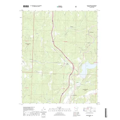
2020 Map of Mountainburg
USGS Topo · Published 2020About this map
Frog Bayou carves a deep valley through the southern reaches of the Ozark National Forest in Crawford County, anchoring a landscape defined by sharp ridges and narrow hollows. The town of Mountainburg sits at the southern edge of this rugged corridor, while the small community of Chester and the settlement at Schaberg follow the valley floor northward. This modern survey illustrates the enduring relationship between the terrain and transportation, where the Boston Mountain Multi-Use Trail and historic corridors like Old 12 Crossroads wind around high points like Gaylor Mtn and Cartwright Mtn. Water management is prominent in the eastern section of the map, featuring both Lake Shepherd Springs and the northern tip of Lake Fort Smith. Local heritage is preserved in several family and community burial grounds, including Basham Memorial Cem and Hillcrest Cem, which remain as quiet landmarks amid the dense forest cover.
Find a feature on this map
84 named features on this map. Tap any name to fly to it.
Don’t see what you’re looking for? This feature index may not catch every label — zoom into the map to look around manually.
Map Details
Editions of this 2020 Mountainburg Map
This is the sole edition of this map. No revisions or reprints were ever made.
Other maps of this area

1898 · Winslow #4
USGS Topo · 1:62,500

1898 · Winslow #3
USGS Topo · 1:62,500

1898 · Winslow
USGS Topo · 1:125,000

1901 · Winslow
USGS Topo · 1:125,000

1946 · Fort Smith
USGS Topo · 1:250,000

1965 · Fort Smith
USGS Topo · 1:250,000

1967 · Fort Smith
USGS Topo · 1:250,000
1969 · Mountainburg SW
USGS Topo · 1:24,000
1969 · Fern
USGS Topo · 1:24,000
1969 · Rudy
USGS Topo · 1:24,000