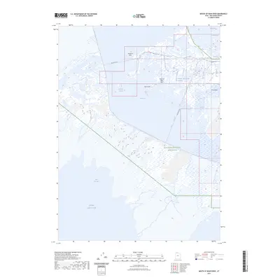
2023 Map of Mouth of Bear River
USGS Topo · Published 2023About this map
The Bear River Migratory Bird Refuge dominates this ecological corridor where the Bear River meets the northeastern reaches of the Great Salt Lake. This map details a complex hydrological landscape of shifting channels and marshlands, including the Old River Channel and the specific confluence at the Mouth of Bear River. Distinctive landforms such as Mushback Point, Pintail Neck, and Rock Island provide high ground amidst the expansive wetlands. The presence of Blodgetts Overflow and Bens Overflow indicates the intricate water management required in this migratory habitat. Access is primarily defined by the Bird Refuge Rd, which traverses the sanctuary through South Bay and toward East Pass, providing a clear record of the infrastructure supporting one of Utah's most significant avian environments.
Find a feature on this map
16 named features on this map. Tap any name to fly to it.
Don’t see what you’re looking for? This feature index may not catch every label — zoom into the map to look around manually.
Map Details
Editions of this 2023 Mouth of Bear River Map
This is the sole edition of this map. No revisions or reprints were ever made.
Other maps of this area

1954 · Whistler Canal
USGS Topo · 1:24,000

1954 · Public Shooting Grounds
USGS Topo · 1:24,000

1954 · Brigham City
USGS Topo · 1:250,000

1955 · Willard Spur
USGS Topo · 1:24,000

1955 · Mouth of Bear River
USGS Topo · 1:24,000

1955 · Plain City SW
USGS Topo · 1:24,000

1955 · Bear River City
USGS Topo · 1:24,000

1958 · Brigham City
USGS Topo · 1:250,000

1961 · Thatcher Mountain
USGS Topo · 1:62,500

1962 · Brigham City
USGS Topo · 1:250,000