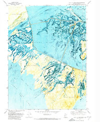
1972 Map of Mouth of Bear River
USGS Topo · Published 1974About this map
Bear River Migratory Bird Refuge dominates this 1970s orthophotomosaic, where the complex delta of the Bear River meets the expansive North Bay and South Bay of the Great Salt Lake. This specialized survey, which uses aerial photography to depict the intricate hydrology of the marshlands, reveals the delicate balance of the environment before shifting lake levels altered the shoreline. The map documents the infrastructure of the refuge, including Refuge Headquarters and a nearby Landing Strip.
Find a feature on this map
21 named features on this map. Tap any name to fly to it.
Don’t see what you’re looking for? This feature index may not catch every label — zoom into the map to look around manually.
Map Details
Editions of this 1972 Mouth of Bear River Map
This is the sole edition of this map. No revisions or reprints were ever made.
Other maps of this area

1954 · Whistler Canal
USGS Topo · 1:24,000

1954 · Public Shooting Grounds
USGS Topo · 1:24,000

1954 · Brigham City
USGS Topo · 1:250,000

1955 · Willard Spur
USGS Topo · 1:24,000

1955 · Mouth of Bear River
USGS Topo · 1:24,000

1955 · Plain City SW
USGS Topo · 1:24,000

1955 · Bear River City
USGS Topo · 1:24,000

1958 · Brigham City
USGS Topo · 1:250,000

1961 · Thatcher Mountain
USGS Topo · 1:62,500

1962 · Brigham City
USGS Topo · 1:250,000