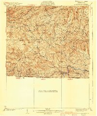
1940 Map of Mouth of Wilson
USGS Topo · Published 1940About this map
Iron Mountain and the surrounding highlands dominate this 1930s-era survey of the borderlands between Virginia and North Carolina. The landscape is defined by a dense network of mountain ridges including Stone Mountain and Haw Orchard Mtn, where small communities like Troutdale and Fairwood are situated along the valley floors. The mapping of numerous rural institutions such as Rockbridge Sch, Bethel Sch, and Burton Chapel suggests a decentralized settlement pattern focused on local schoolhouses and churches that served isolated hollows.
Find a feature on this map
119 named features on this map. Tap any name to fly to it.
Don’t see what you’re looking for? This feature index may not catch every label — zoom into the map to look around manually.
Map Details
Editions of this 1940 Mouth of Wilson Map
3 editions found


Other maps of this area

1889 · Wytheville
USGS Topo · 1:125,000

1889 · Wilkesboro
USGS Topo · 1:125,000

1891 · Abingdon
USGS Topo · 1:125,000

1891 · Wilkesboro
USGS Topo · 1:125,000

1892 · Wytheville
USGS Topo · 1:125,000

1893 · Cranberry
USGS Topo · 1:125,000

1894 · Abingdon
USGS Topo · 1:125,000

1895 · Cranberry
USGS Topo · 1:125,000

1899 · Cranberry
USGS Topo · 1:125,000

1902 · Cranberry
USGS Topo · 1:125,000