
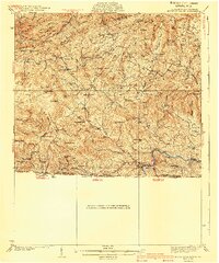
1940 Map of Mouth of Wilson
USGS Topo · Published 1940About this map
Iron Mountain and the crests of the Blue Ridge dominate this 1940 survey of Grayson County, Virginia, and the adjacent North Carolina border. The landscape is defined by its high-altitude peaks, including First Peak, Second Peak, and Third Peak, which overlook a network of isolated rural settlements and creek valleys. Early 20th-century life is etched into the terrain through a high density of local institutions, from Burton Chapel to the County Home, along with numerous neighborhood schoolhouses like Rockbridge Sch and Little Wilson Sch. At the southern edge, the New River snakes through the valley near the community of Mouth of Wilson, serving as a vital geographical anchor for the region. This map illustrates the transition from high timbered ridges like Hickory Ridge to the bottomland farming communities at Grant and Volney, before the modernization of the road network significantly altered these highland corridors.
Find a feature on this map
89 named features on this map. Tap any name to fly to it.
Don’t see what you’re looking for? This feature index may not catch every label — zoom into the map to look around manually.
Map Details
Editions of this 1940 Mouth of Wilson Map
3 editions found

Other maps of this area

1889 · Wytheville
USGS Topo · 1:125,000

1889 · Wilkesboro
USGS Topo · 1:125,000

1891 · Abingdon
USGS Topo · 1:125,000

1891 · Wilkesboro
USGS Topo · 1:125,000

1892 · Wytheville
USGS Topo · 1:125,000

1893 · Cranberry
USGS Topo · 1:125,000

1894 · Abingdon
USGS Topo · 1:125,000

1895 · Cranberry
USGS Topo · 1:125,000

1899 · Cranberry
USGS Topo · 1:125,000

1902 · Cranberry
USGS Topo · 1:125,000