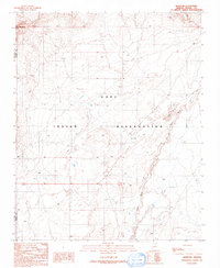
1991 Map of Mowa'api
USGS Topo · Published 1991About this map
The Hopi Indian Reservation landscape is defined by the ephemeral Oraibi Wash, which winds through a territory marked by water scarcity and traditional land use. In this high desert environment, the settlement of Mowa'api and scattered infrastructure like the Flute Well (Dry) and several Water Tank locations reveal the critical importance of moisture management. The terrain is characterized by active Sand Dunes and land modifications including various Check Dam installations, likely intended to control erosion and capture seasonal runoff. Industrial activity is present through the Gravel Pit and a Drill Hole, while the boundary of Coconino Co Navajo Co runs along the western edge of the quadrangle, illustrating the political geography superimposed on this arid landscape.
Find a feature on this map
12 named features on this map. Tap any name to fly to it.
Don’t see what you’re looking for? This feature index may not catch every label — zoom into the map to look around manually.
Map Details
Editions of this 1991 Mowa'api Map
This is the sole edition of this map. No revisions or reprints were ever made.
Other maps of this area

1883 · Tusayan
USGS Topo · 1:250,000

1886 · Tusayan
USGS Topo · 1:250,000

1947 · Flagstaff
USGS Topo · 1:250,000

1954 · Flagstaff
USGS Topo · 1:250,000

1958 · Flagstaff
USGS Topo · 1:250,000

1960 · Flagstaff
USGS Topo · 1:250,000

1962 · Flagstaff
USGS Topo · 1:250,000

1966 · Oraibi
USGS Topo · 1:62,500

1966 · Tovar Mesa
USGS Topo · 1:62,500
1967 · Howell Mesa
USGS Topo · 1:24,000