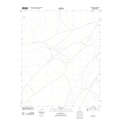
2011 Map of Mowaapi
USGS Topo · Published 2011About this map
Mowaapi sits at the heart of this high-desert landscape in the early 2010s, serving as a primary point of reference within the Hopi Indian Reservation. The area's character is defined by a network of critical transit routes that cross the arid terrain, including Indian Rte 13, which provides essential connectivity through this section of Navajo County. The convergence of Hopi Reservation Rd and the Leupp-Oraibi Rd illustrates the historical and contemporary pathways used by local communities. While the settlement at Mowaapi is the primary namesake, the map reveals a vast, open landscape where topography is dictated by seasonal drainages and the enduring infrastructure of tribal roads.
Find a feature on this map
4 named features on this map. Tap any name to fly to it.
Don’t see what you’re looking for? This feature index may not catch every label — zoom into the map to look around manually.
Map Details
Editions of this 2011 Mowaapi Map
This is the sole edition of this map. No revisions or reprints were ever made.
Other maps of this area

1883 · Tusayan
USGS Topo · 1:250,000

1886 · Tusayan
USGS Topo · 1:250,000

1947 · Flagstaff
USGS Topo · 1:250,000

1954 · Flagstaff
USGS Topo · 1:250,000

1958 · Flagstaff
USGS Topo · 1:250,000

1960 · Flagstaff
USGS Topo · 1:250,000

1962 · Flagstaff
USGS Topo · 1:250,000

1966 · Oraibi
USGS Topo · 1:62,500

1966 · Tovar Mesa
USGS Topo · 1:62,500
1967 · Howell Mesa
USGS Topo · 1:24,000