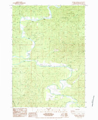
1984 Map of Mowrey Landing
USGS Topo · Published 1984About this map
The Siletz River winds through this coastal Oregon landscape, defining a corridor of small river landings and agricultural clearings within the Siuslaw National Forest. In the mid-1980s, the river served as a central artery for the community, marked by numerous small access points like Melco Landing, Mack Landing, Morgan Landing, and Mowrey Landing. The presence of the Reed Creek Grange and the open expanse of Camas Prairie suggest a durable history of local gathering and farming along the river benches, even as timber and topography dominate the surrounding terrain.
Find a feature on this map
39 named features on this map. Tap any name to fly to it.
Don’t see what you’re looking for? This feature index may not catch every label — zoom into the map to look around manually.
Map Details
Editions of this 1984 Mowrey Landing Map
This is the sole edition of this map. No revisions or reprints were ever made.
Other maps of this area

1941 · Cape Foulweather
USGS Topo · 1:62,500

1942 · Euchre Mtn
USGS Topo · 1:62,500

1942 · Yaquina
USGS Topo · 1:62,500

1942 · Toledo
USGS Topo · 1:62,500

1943 · Euchre Mtn
USGS Topo · 1:62,500

1944 · Cape Foulweather
USGS Topo · 1:62,500

1953 · Salem
USGS Topo · 1:250,000

1954 · Salem
USGS Topo · 1:250,000

1957 · Cape Foulweather
USGS Topo · 1:62,500

1957 · Yaquina
USGS Topo · 1:62,500