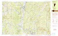
1984 Map of Mt. Ascutney
USGS Topo · Published 1984About this map
The Connecticut River serves as the central artery of this 1980s landscape, dividing Windsor, Vermont from the rolling New Hampshire hills of Cornish Town. The industrial and transport history of the valley is evident in the path of the Central Vermont and Boston and Maine railroads, which parallel the water and connect settlements like Claremont and West Claremont. To the west, the massive profile of Mt Ascutney dominates the terrain, surrounded by the protected lands of Ascutney State Park. The map documents a blend of cultural and civic landmarks, from the Saint Gaudens National Historic Site to the Residential Treatment Facility (Prison) and the State Vocational Technical College. Smaller hamlets like Brownsville and Sheddsville remain tucked into the highlands, while numerous water bodies such as Lake Runnemede and Dole Reservoir punctuate the wooded valleys.
Find a feature on this map
78 named features on this map. Tap any name to fly to it.
Don’t see what you’re looking for? This feature index may not catch every label — zoom into the map to look around manually.
Map Details
Editions of this 1984 Mt. Ascutney Map
2 editions found
Other maps of this area

1902 · Sunapee
USGS Topo · 1:62,500

1905 · Sunapee
USGS Topo · 1:62,500

1906 · Hanover
USGS Topo · 1:62,500

1907 · Sunapee
USGS Topo · 1:62,500

1908 · Hanover
USGS Topo · 1:62,500

1911 · Woodstock
USGS Topo · 1:62,500

1913 · Woodstock
USGS Topo · 1:62,500

1926 · Claremont
USGS Topo · 1:62,500

1927 · Mascoma
USGS Topo · 1:62,500

1928 · Ludlow
USGS Topo · 1:48,000