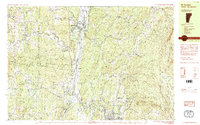
1984 Map of Mt. Ascutney
USGS Topo · Published 1984About this map
The Connecticut River serves as the central artery and state boundary for this 1980s-era topographical survey, which covers the rugged Vermont-New Hampshire borderlands. On the Vermont side, the massive rise of Mt Ascutney dominates the landscape, protected within Ascutney State Park and neighboring wildlife management areas. The town of Windsor occupies the river plain, showing a mix of institutional and civic life through labels like the Mt Ascutney Hospital and a Residential Treatment Facility (Prison).
Find a feature on this map
79 named features on this map. Tap any name to fly to it.
Don’t see what you’re looking for? This feature index may not catch every label — zoom into the map to look around manually.
Map Details
Editions of this 1984 Mt. Ascutney Map
2 editions found
Other maps of this area

1902 · Sunapee
USGS Topo · 1:62,500

1905 · Sunapee
USGS Topo · 1:62,500

1906 · Hanover
USGS Topo · 1:62,500

1907 · Sunapee
USGS Topo · 1:62,500

1908 · Hanover
USGS Topo · 1:62,500

1911 · Woodstock
USGS Topo · 1:62,500

1913 · Woodstock
USGS Topo · 1:62,500

1926 · Claremont
USGS Topo · 1:62,500

1927 · Mascoma
USGS Topo · 1:62,500

1928 · Ludlow
USGS Topo · 1:48,000