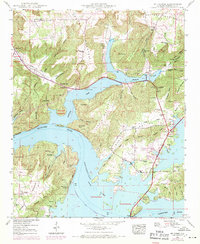
1948 Map of Mt Carmel
USGS Topo · Published 1971About this map
Guntersville Lake dominates this Alabama landscape, where the Tennessee River flows through a complex geography of ridges and flooded hollows. The Tennessee Valley Authority (TVA) mapped the region in the late 1940s, documenting a time when river transport and local agriculture were intersecting with new infrastructure like the Houston Bridge and Guntersville Municipal Airport. The map shows how the impounded waters created numerous fingers of land and islands, such as Buck Island and Goat Island, while carving out distinct points like Ft Deposit Point and Hale Point.
Find a feature on this map
73 named features on this map. Tap any name to fly to it.
Don’t see what you’re looking for? This feature index may not catch every label — zoom into the map to look around manually.
Map Details
Editions of this 1948 Mt Carmel Map
3 editions found
Other maps of this area

1885 · Gadsden
USGS Topo · 1:125,000

1888 · Gadsden
USGS Topo · 1:125,000

1888 · Scottsboro
USGS Topo · 1:125,000

1892 · Scottsboro
USGS Topo · 1:125,000

1892 · Gadsden
USGS Topo · 1:125,000

1895 · Gadsden
USGS Topo · 1:125,000

1903 · Gadsden
USGS Topo · 1:125,000

1936 · Guntersville
USGS Topo · 1:24,000

1936 · Columbus City
USGS Topo · 1:24,000

1936 · New Hope
USGS Topo · 1:24,000