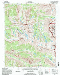
1994 Map of Mt. Clarence King
USGS Topo · Published 1997About this map
Mount Clarence King stands as a central peak in this high-altitude survey of the Sierra Nevada, marking a landscape defined by dramatic glaciation and alpine hydrology. The map captures the convergence of major wilderness corridors within Kings Canyon National Park, specifically where the John Muir Trail traverses the spine of the range. The drainage patterns of Woods Creek, Bubbs Creek, and Charlotte Creek reveal the complex topography that historically challenged early explorers and later provided the backbone for the region's wilderness recreation infrastructure. Strategic mountain passes, such as Kearsarge Pass on the border of the Inyo National Forest and Glen Pass near the Rae Lakes basin, illustrate the established routes used to navigate these granite heights. Lower-lying features like Vidette Meadow and Junction Meadow serve as vital landmarks for those tracking the historical development of trail systems in the High Sierra during the late twentieth century.
Find a feature on this map
42 named features on this map. Tap any name to fly to it.
Don’t see what you’re looking for? This feature index may not catch every label — zoom into the map to look around manually.
Map Details
Editions of this 1994 Mt. Clarence King Map
This is the sole edition of this map. No revisions or reprints were ever made.
Other maps of this area

1903 · Tehipite
USGS Topo · 1:125,000

1905 · Tehipite
USGS Topo · 1:125,000

1907 · Mt. Whitney
USGS Topo · 1:125,000

1919 · Mt. Whitney
USGS Topo · 1:125,000

1937 · Mt. Whitney
USGS Topo · 1:125,000

1948 · Fresno
USGS Topo · 1:250,000

1953 · Mt. Pinchot
USGS Topo · 1:62,500

1953 · Marion Peak
USGS Topo · 1:62,500

1955 · Fresno
USGS Topo · 1:250,000

1956 · Fresno
USGS Topo · 1:250,000