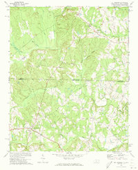
1970 Map of Mt. Croghan
USGS Topo · Published 1973About this map
Mt Croghan and the surrounding borderlands of the Carolinas appear here just as the 1970s began, showing a landscape defined by small rural congregations and intersecting watercourses. The map traces the winding paths of Deep Creek and Thompson Creek as they flow through the Piedmont, connecting scattered communities like Wexford and Maysville. Numerous local landmarks, such as Elizabeth Ch and Davidson Grove Ch, suggest the social centerpieces of these rural neighborhoods, while the state line between North and South Carolina bisects the sheet, separating Anson and Chesterfield counties.
Find a feature on this map
36 named features on this map. Tap any name to fly to it.
Don’t see what you’re looking for? This feature index may not catch every label — zoom into the map to look around manually.
Map Details
Editions of this 1970 Mt. Croghan Map
2 editions found
Other maps of this area

1941 · Spartanburg
USGS Topo · 1:250,000

1953 · Spartanburg
USGS Topo · 1:250,000

1956 · Wadesboro
USGS Topo · 1:24,000

1960 · Spartanburg
USGS Topo · 1:250,000

1963 · Spartanburg
USGS Topo · 1:250,000

1964 · Spartanburg
USGS Topo · 1:250,000

1968 · Chesterfield
USGS Topo · 1:24,000

1968 · Ruby
USGS Topo · 1:24,000

1968 · Jefferson NE
USGS Topo · 1:24,000

1970 · Marshville
USGS Topo · 1:24,000