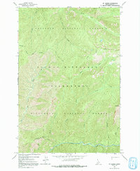
1966 Map of Mt George
USGS Topo · Published 1991About this map
The Nez Perce National Forest and Bitterroot National Forest converge in this high-altitude 1966 survey, defined by the protected boundaries of the Selway Bitterroot Wilderness. A complex drainage system feeds into White Cap Creek, including high mountain streams like Bad Luck Creek, Fry Pan Creek, and South Fork Creek. Human infrastructure is sparse and oriented toward fire surveillance and backcountry travel, anchored by the Bad Luck Lookout Tower and a series of primitive Pack Trails that cross the ridges. Named peaks such as Mt George and Cub Point punctuate a landscape where the National Forest Boundary remains indefinite in certain reaches, reflecting the raw, transitionary nature of the Idaho backcountry during the mid-1960s.
Find a feature on this map
21 named features on this map. Tap any name to fly to it.
Don’t see what you’re looking for? This feature index may not catch every label — zoom into the map to look around manually.
Map Details
Editions of this 1966 Mt George Map
2 editions found
Other maps of this area

1911 · Lolo
USGS Topo · 1:250,000

1913 · Lolo
USGS Topo · 1:250,000

1956 · Elk City
USGS Topo · 1:250,000

1956 · Hamilton
USGS Topo · 1:250,000

1959 · Hamilton
USGS Topo · 1:250,000

1960 · Elk City
USGS Topo · 1:250,000

1960 · Hamilton
USGS Topo · 1:250,000

1964 · Hamilton
USGS Topo · 1:250,000

1966 · Watchtower Peak
USGS Topo · 1:24,000

1966 · Spot Mountain
USGS Topo · 1:24,000