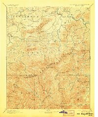
1893 Map of Mt Guyot
USGS Topo · Published 1906About this map
Mt Guyot and the surrounding massifs dominate this survey of the Tennessee and North Carolina borderlands, reflecting a landscape defined by sharp elevation and isolated river settlements before the establishment of modern park boundaries. The Virginia and Georgia Railroad snakes through the northern reaches near Newport, tracking the course of the French Broad River, while further west, Elliot Ferry marks a critical river crossing near Hickory Ridge.
Find a feature on this map
120 named features on this map. Tap any name to fly to it.
Don’t see what you’re looking for? This feature index may not catch every label — zoom into the map to look around manually.
Map Details
Editions of this 1893 Mt Guyot Map
3 editions found
Other maps of this area

1883 · Morristown
USGS Topo · 1:125,000

1886 · Knoxville
USGS Topo · 1:125,000

1891 · Cowee
USGS Topo · 1:125,000

1892 · Greeneville
USGS Topo · 1:125,000

1892 · Knoxville
USGS Topo · 1:125,000

1893 · Mt Guyot
USGS Topo · 1:125,000

1893 · Morristown
USGS Topo · 1:125,000

1894 · Asheville
USGS Topo · 1:125,000

1894 · Knoxville
USGS Topo · 1:125,000

1895 · Morristown
USGS Topo · 1:125,000