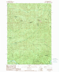
1989 Map of Mt. Hagan
USGS Topo · Published 1989About this map
Mc Kenzie River flows through the southern reaches of this landscape, marking a transition from the dense interior of the Willamette National Forest to the managed state lands of Howard J Morton State Park. The map captures the complex drainage systems of the Cascade foothills in the late 1980s, where the Calapooia River and its numerous forks carve through timberland. Notable peaks like Mt Hagan and Jimbo Mountain dominate the central topography, while King Camp serves as a lone named outpost in the north. The presence of the Rail Trail and extensive transmission lines indicates the intersection of recreational passage and industrial infrastructure. This survey is particularly useful for tracking specific watercourses, from United States Creek to the curiously named Wet Gulch, providing a clear record of the area's hydrology before modern changes to the forest canopy.
Find a feature on this map
29 named features on this map. Tap any name to fly to it.
Don’t see what you’re looking for? This feature index may not catch every label — zoom into the map to look around manually.
Map Details
Editions of this 1989 Mt. Hagan Map
This is the sole edition of this map. No revisions or reprints were ever made.
Other maps of this area

1934 · Mc Kenzie Bridge
USGS Topo · 1:96,000

1940 · Mc Kenzie Bridge
USGS Topo · 1:125,000

1951 · Sweet Home
USGS Topo · 1:62,500

1951 · Leaburg
USGS Topo · 1:62,500

1953 · Salem
USGS Topo · 1:250,000

1954 · Salem
USGS Topo · 1:250,000

1955 · Blue River
USGS Topo · 1:62,500

1955 · Cascadia
USGS Topo · 1:62,500

1960 · Salem
USGS Topo · 1:250,000

1962 · Salem
USGS Topo · 1:250,000