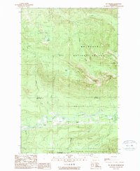
1989 Map of Mt Higgins
USGS Topo · Published 1989About this map
The North Fork Stillaguamish River corridor defines the southern half of this map, serving as the primary artery for transport and settlement in the late 1980s. Small hamlets like Hazel and Rowan line the valley floor, positioned near the river's edge and the surrounding timberlands. To the north, the landscape rises sharply into the Mt Baker National Forest, where peaks like Mt Higgins and Skadulgwas Peak dominate the high country. This transition from the industrial activity of a valley Quarry to the protected high-altitude terrain of the Boulder River Wilderness highlights the region's duality of resource extraction and conservation. Unique hydrological features such as the Granite Lake Potholes, Blue Pool, and the whimsically named McGillicuddys Duck Pond are scattered throughout the northern drainage of Deer Creek.
Find a feature on this map
29 named features on this map. Tap any name to fly to it.
Don’t see what you’re looking for? This feature index may not catch every label — zoom into the map to look around manually.
Map Details
Editions of this 1989 Mt Higgins Map
This is the sole edition of this map. No revisions or reprints were ever made.
Other maps of this area

1899 · Stillaguamish
USGS Topo · 1:125,000

1901 · Stilaguamish
USGS Topo · 1:125,000

1955 · Concrete
USGS Topo · 1:250,000

1956 · Oso
USGS Topo · 1:62,500

1956 · Granite Falls
USGS Topo · 1:62,500

1957 · Silverton
USGS Topo · 1:62,500

1958 · Concrete
USGS Topo · 1:250,000

1962 · Concrete
USGS Topo · 1:250,000
1966 · Fortson
USGS Topo · 1:24,000
1966 · Finney Peak
USGS Topo · 1:24,000