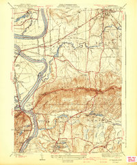
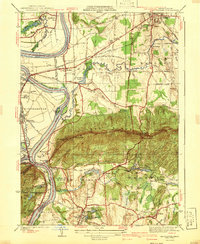
1941 Map of Mt Holyoke
USGS Topo · Published 1941About this map
The Connecticut River carves a dramatic path through the Pioneer Valley on this 1941 survey, defining the agricultural and institutional character of the region. The map highlights the significant academic presence of Amherst College and Mt Holyoke College, situated within a landscape of productive bottomlands like Hockanum Flat and upland peaks. The Holyoke Range dominates the central terrain, punctuated by summits like Mt Hitchcock and the geological curiosity of the Devils Garden.
Find a feature on this map
89 named features on this map. Tap any name to fly to it.
Don’t see what you’re looking for? This feature index may not catch every label — zoom into the map to look around manually.
Map Details
Editions of this 1941 Mt Holyoke Map
3 editions found

Other maps of this area

1885 · Northampton
USGS Topo · 1:62,500

1886 · Springfield
USGS Topo · 1:62,500

1886 · Northampton
USGS Topo · 1:62,500

1887 · Palmer
USGS Topo · 1:62,500

1887 · Belchertown
USGS Topo · 1:62,500

1889 · Springfield
USGS Topo · 1:62,500

1889 · Palmer
USGS Topo · 1:62,500

1890 · Belchertown
USGS Topo · 1:62,500

1891 · Northampton
USGS Topo · 1:62,500

1893 · Northampton
USGS Topo · 1:62,500