
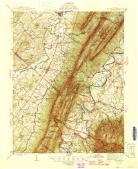
1946 Map of Mt Jackson
USGS Topo · Published 1946About this map
Massanutten Mountain dominates this mid-century portrait of the Shenandoah Valley, creating a formidable physical barrier between the North Fork and South Fork Shenandoah River. Along the western valley floor, the Lee Highway and Southern Railway link established agrarian hubs like New Market and Mt Jackson. The geography is defined by a dense network of small community anchors, including the Shenandoah Academy and numerous rural houses of worship such as Cedar Grove Ch and St Pauls Ch.
Find a feature on this map
106 named features on this map. Tap any name to fly to it.
Don’t see what you’re looking for? This feature index may not catch every label — zoom into the map to look around manually.
Map Details
Editions of this 1946 Mt Jackson Map
2 editions found
Other maps of this area

1892 · Woodstock
USGS Topo · 1:125,000

1892 · Gordonsville
USGS Topo · 1:125,000

1892 · Harrisonburg
USGS Topo · 1:125,000

1893 · Luray
USGS Topo · 1:125,000

1905 · Luray
USGS Topo · 1:125,000

1921 · Orkney Springs
USGS Topo · 1:48,000

1923 · Orkney Springs
USGS Topo · 1:62,500

1923 · Edinburg
USGS Topo · 1:62,500

1929 · Stony Man
USGS Topo · 1:48,000

1930 · Madison
USGS Topo · 1:48,000