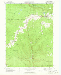
1969 Map of Mt. Jewett
USGS Topo · Published 1973About this map
Mt Jewett serves as the central hub of this 1969 survey, where the Baltimore and Ohio RR network branches across the northern Pennsylvania highlands. The industrial landscape is defined by extensive energy extraction, with a dense concentration of Gas Wells and Oil Wells dotting the hillsides within the Allegheny National Forest and Elk State Forest. Small settlements such as Lantz Corners, Kanesholm, and Halsey are scattered along the highway corridors and rail lines, reflecting the region's reliance on transit and natural resources. Historical landmarks of local importance include Nebo Ch and St Josephs Ch near the main town, while the southern reach of the map follows the course of the Clarion River toward the settlement of Burning Well. The mapping captures a specific moment of rural industrialization, where pipelines and jeep trails intersect with old mountain runs like Kinzua Creek.
Find a feature on this map
45 named features on this map. Tap any name to fly to it.
Don’t see what you’re looking for? This feature index may not catch every label — zoom into the map to look around manually.
Map Details
Editions of this 1969 Mt. Jewett Map
4 editions found
Other maps of this area

1924 · Bradford
USGS Topo · 1:62,500

1926 · Bradford
USGS Topo · 1:62,500

1934 · Kane
USGS Topo · 1:48,000

1935 · Mt. Jewett
USGS Topo · 1:48,000

1936 · Kinzua
USGS Topo · 1:48,000

1939 · Kane
USGS Topo · 1:62,500

1940 · Mt. Jewett
USGS Topo · 1:62,500

1941 · Kinzua
USGS Topo · 1:62,500

1941 · Bradford
USGS Topo · 1:62,500

1944 · Bradford
USGS Topo · 1:62,500
Featured Places
- Mount Jewett, PA
- Cartwrights Crossing, Wetmore Township
- Griffiths, Hamlin Township
- Campbelltown, Hamlin Township
- Wetmore Township, PA