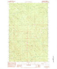
1983 Map of Mt Leona
USGS Topo · Published 1983About this map
Colville National Forest dominates this high-elevation terrain in Ferry County, characterized by a complex drainage system and significant mountain peaks. The landscape is defined by the prominent Mt Leona and the nearby Profanity Peak, which serves as a central landmark for this portion of the range. Numerous watercourses, including West Fork Deer Creek and Boulder Creek, carve through the ridges, reflecting the area's natural hydrology. A network of primitive pathways, such as the Foot Trail near Ryan Hill, suggests a landscape used primarily for forest management and backcountry recreation during the early 1980s. The presence of the Deer Creek Summit Campground near Sentinel Butte indicates established seasonal access points within the timbered reaches of Taylor Ridge and Tendsket Mountain.
Find a feature on this map
31 named features on this map. Tap any name to fly to it.
Don’t see what you’re looking for? This feature index may not catch every label — zoom into the map to look around manually.
Map Details
Editions of this 1983 Mt Leona Map
This is the sole edition of this map. No revisions or reprints were ever made.
Other maps of this area

1904 · Republic
USGS Topo · 1:125,000

1936 · Marcus
USGS Topo · 1:96,000

1942 · Marcus
USGS Topo · 1:125,000

1948 · Curlew
USGS Topo · 1:62,500

1948 · Republic
USGS Topo · 1:62,500

1948 · Sherman Peak
USGS Topo · 1:62,500

1948 · Togo Mountain
USGS Topo · 1:62,500

1951 · Togo Mountain
USGS Topo · 1:62,500

1951 · Sherman Peak
USGS Topo · 1:62,500

1951 · Curlew
USGS Topo · 1:62,500