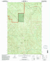
1992 Map of Mt. Leona
USGS Topo · Published 1996About this map
The high ridges of the Kettle River Range dominate this northern Washington landscape, which is managed as part of the Colville National Forest. The geography is defined by prominent peaks including Mt Leona, Profanity Peak, and Tonasket Mountain. These elevations separate numerous drainages such as West Fork Boulder Creek, Indian Creek, and Butte Creek. Human activity is primarily centered on the Kettle Falls Republic Road, which crosses through Deer Creek Summit. Evidence of resource extraction and local infrastructure is present via several prospects and a Borrow Pit located near the road. The map also records the boundary between the Republic Ranger District and the Curlew District, providing a detailed look at forest management divisions in Ferry County during the early 1990s.
Find a feature on this map
30 named features on this map. Tap any name to fly to it.
Don’t see what you’re looking for? This feature index may not catch every label — zoom into the map to look around manually.
Map Details
Editions of this 1992 Mt. Leona Map
This is the sole edition of this map. No revisions or reprints were ever made.
Other maps of this area

1904 · Republic
USGS Topo · 1:125,000

1936 · Marcus
USGS Topo · 1:96,000

1942 · Marcus
USGS Topo · 1:125,000

1948 · Curlew
USGS Topo · 1:62,500

1948 · Republic
USGS Topo · 1:62,500

1948 · Sherman Peak
USGS Topo · 1:62,500

1948 · Togo Mountain
USGS Topo · 1:62,500

1951 · Togo Mountain
USGS Topo · 1:62,500

1951 · Sherman Peak
USGS Topo · 1:62,500

1951 · Curlew
USGS Topo · 1:62,500