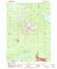
1988 Map of Mt. Mc Loughlin
USGS Topo · Published 1988About this map
Mt Mc Loughlin dominates this high-elevation landscape, standing as a primary landmark at the junction of the Rogue River National Forest, Winema National Forest, and the Sky Lakes Wilderness. This 1988 map documents the region's recreational and hydrologic character, from the Fish Lake Resort and Doe Point campgrounds along Fish Lake to the secluded waters of Fourmile Lake and Summit Lake. The rugged terrain is punctuated by distinctive peaks like North Squaw Tip and South Squaw Tip, while a heavy concentration of volcanic Lava flows is mapped in the southeastern corner near the Jackson and Klamath county line. Infrastructure for water management and transit is visible through the Gaging Station on Little Butte Creek and the route of the Pacific Crest National Scenic Trail.
Find a feature on this map
39 named features on this map. Tap any name to fly to it.
Don’t see what you’re looking for? This feature index may not catch every label — zoom into the map to look around manually.
Map Details
Editions of this 1988 Mt. Mc Loughlin Map
This is the sole edition of this map. No revisions or reprints were ever made.
Other maps of this area

1891 · Ashland
USGS Topo · 1:250,000

1893 · Ashland
USGS Topo · 1:250,000

1897 · Ashland
USGS Topo · 1:250,000

1955 · Lake O' Woods
USGS Topo · 1:62,500

1955 · Rustler Peak
USGS Topo · 1:62,500

1955 · Mt. Mc Loughlin
USGS Topo · 1:62,500

1955 · Pelican Butte
USGS Topo · 1:62,500

1955 · Medford
USGS Topo · 1:250,000

1957 · Medford
USGS Topo · 1:250,000

1958 · Medford
USGS Topo · 1:250,000