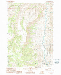
1990 Map of Mt. Misery
USGS Topo · Published 1990About this map
John Day Fossil Beds National Monument anchors the southeastern portion of this landscape, where the geology of central Oregon meets the winding path of the John Day River. This territory, surveyed for the 1990 provisional edition, reflects the drainage patterns of the high desert, characterized by numerous seasonal and perennial flows like Hide and Seek Creek, McGinnis Creek, and Deep Creek. The prominent height of Mt Misery overlooks a network of canyons and basins, including the notable Artman Basin and Bull Canyon. Small water sources such as Black Snag Springs and various named landmarks like Cathedral Rock near Devils Gulch provide specific points of reference for those studying the land use and natural landmarks within Wheeler and Grant counties.
Find a feature on this map
29 named features on this map. Tap any name to fly to it.
Don’t see what you’re looking for? This feature index may not catch every label — zoom into the map to look around manually.
Map Details
Editions of this 1990 Mt. Misery Map
This is the sole edition of this map. No revisions or reprints were ever made.
Other maps of this area

1953 · Richmond
USGS Topo · 1:62,500

1953 · Kimberly
USGS Topo · 1:62,500

1953 · Picture
USGS Topo · 1:62,500

1953 · Spray
USGS Topo · 1:62,500

1955 · Canyon City
USGS Topo · 1:250,000

1959 · Canyon City
USGS Topo · 1:250,000

1980 · Monument
USGS Topo · 1:100,000
1990 · Miller Flat
USGS Topo · 1:24,000
1990 · Tubb Spring
USGS Topo · 1:24,000
1990 · Picture Gorge West
USGS Topo · 1:24,000