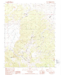
1987 Map of Mt. Montgomery
USGS Topo · Published 1987About this map
The high peaks of the White Mountains and the boundary between Mineral and Esmeralda counties define this high-altitude landscape. A legacy of mineral extraction is visible throughout the terrain, with numerous mining operations concentrated along Queen Canyon and the surrounding ridges. These include the Queen Canyon Mine, Albert Mine, and Morgan Mine, as well as the Gold Hit (Site) near Sugarloaf Canyon. Transport across the difficult terrain is evidenced by the Old Railroad Grade winding through the northern portion of the map near Mt Montgomery. The land transitions from the industrial activity of the mines into the protected expanse of the Inyo National Forest, where water sources like Pinchot Springs and Sagehen Spring provide vital points in the arid environment.
Find a feature on this map
36 named features on this map. Tap any name to fly to it.
Don’t see what you’re looking for? This feature index may not catch every label — zoom into the map to look around manually.
Map Details
Editions of this 1987 Mt. Montgomery Map
This is the sole edition of this map. No revisions or reprints were ever made.
Other maps of this area

1909 · Hawthorne
USGS Topo · 1:250,000

1911 · Hawthorne
USGS Topo · 1:250,000

1915 · Hawthorne
USGS Topo · 1:250,000

1917 · White Mountain
USGS Topo · 1:125,000

1947 · Mariposa
USGS Topo · 1:250,000

1948 · Walker Lake
USGS Topo · 1:250,000

1948 · Mariposa
USGS Topo · 1:250,000

1957 · Walker Lake
USGS Topo · 1:250,000

1957 · Mariposa
USGS Topo · 1:250,000

1962 · Walker Lake
USGS Topo · 1:250,000