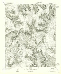
1953 Map of Mt Pennell 2 NW
USGS Topo · Published 1955About this map
Tarantula Mesa and Swap Mesa dominate this topography, where the high plateaus of Garfield County drop away into a complex network of canyons and drainage systems. This 1950s survey captures the region just as photogrammetric mapping began to reveal the intricate landforms of south-central Utah in high detail. The map traces the winding course of Muley Twist Creek as it carves through the sandstone, creating a stark corridor between the elevated plateaus and the broad expanses of Cave Flat. The absence of roads or settlements on this sheet reflects the remote character of the Colorado Plateau before modern recreational infrastructure became established in the area.
Find a feature on this map
4 named features on this map. Tap any name to fly to it.
Don’t see what you’re looking for? This feature index may not catch every label — zoom into the map to look around manually.
Map Details
Editions of this 1953 Mt Pennell 2 NW Map
This is the sole edition of this map. No revisions or reprints were ever made.
Other maps of this area

1885 · San Rafael
USGS Topo · 1:250,000

1885 · Fish Lake
USGS Topo · 1:250,000

1886 · Escalante
USGS Topo · 1:250,000

1886 · Henry Mountains
USGS Topo · 1:250,000

1892 · Henry Mountains
USGS Topo · 1:250,000

1896 · Fish Lake
USGS Topo · 1:250,000

1952 · Notom 4 SE
USGS Topo · 1:24,000

1952 · Mt Pennell 2 NE
USGS Topo · 1:24,000

1952 · Notom
USGS Topo · 1:62,500

1953 · Mt Pennell
USGS Topo · 1:62,500