
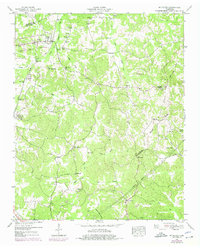
1949 Map of Mt. Peter
USGS Topo · Published 1952About this map
Finger serves as a primary rail settlement in this post-war landscape, situated along the Mobile and Ohio railroad corridor. The area is defined by the Tennessee Valley Divide, which cuts through the undulating terrain of Chester and McNairy Counties. This ridge separates the headwaters of numerous small streams, including Huggins Creek and Bilkes Creek, creating a network of localized valley communities. Local social life is anchored by a dense distribution of rural institutions, such as Mt Carmel Ch, Liberty Ch, and Iola Sch, many of which were central to these dispersed farming neighborhoods.
Find a feature on this map
73 named features on this map. Tap any name to fly to it.
Don’t see what you’re looking for? This feature index may not catch every label — zoom into the map to look around manually.
Map Details
Editions of this 1949 Mt. Peter Map
2 editions found
Other maps of this area

1936 · Leapwood
USGS Topo · 1:24,000

1936 · Enville
USGS Topo · 1:24,000

1936 · Purdy
USGS Topo · 1:24,000

1936 · Stantonville
USGS Topo · 1:24,000

1936 · Mt. Peter
USGS Topo · 1:24,000

1949 · Leapwood
USGS Topo · 1:24,000

1949 · Purdy
USGS Topo · 1:24,000

1949 · Stantonville
USGS Topo · 1:24,000

1950 · Enville
USGS Topo · 1:24,000

1951 · Rose Creek
USGS Topo · 1:24,000