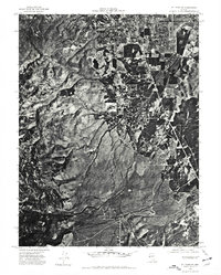
1974 Map of Mt. Rose NE
USGS Topo · Published 1977About this map
Reno expanded southward into the Truckee Meadows during the mid-1970s, as seen in this detailed orthophotograph. The aerial imagery captures the transition from the city's suburban fringes to the open drainage basins of Evans Creek and Thomas Creek. While the northern portion of the sheet shows established residential blocks and the local airport infrastructure, the southern landscape remains dominated by the prominent Steamboat Hills. This perspective provides a clear view of the geographic constraints and hydrological patterns that shaped development on the edge of the high desert. The contrast between the rigid grid of the city and the natural alluvial fans descending from the western mountains illustrates the rapid conversion of ranch land to urban use during this period in Washoe County history.
Find a feature on this map
5 named features on this map. Tap any name to fly to it.
Don’t see what you’re looking for? This feature index may not catch every label — zoom into the map to look around manually.
Map Details
Editions of this 1974 Mt. Rose NE Map
This is the sole edition of this map. No revisions or reprints were ever made.
Other maps of this area

1891 · Carson
USGS Topo · 1:125,000

1891 · Reno
USGS Topo · 1:125,000

1893 · Carson
USGS Topo · 1:125,000

1893 · Reno
USGS Topo · 1:125,000

1950 · Virginia City
USGS Topo · 1:62,500

1950 · Mt. Rose
USGS Topo · 1:62,500

1950 · Reno
USGS Topo · 1:62,500

1951 · Reno
USGS Topo · 1:62,500

1952 · Mt. Rose
USGS Topo · 1:62,500

1952 · Virginia City
USGS Topo · 1:62,500