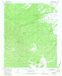
1951 Map of Mt Sedgwick
USGS Topo · Published 1981About this map
Mt Sedgwick Vabm 9256 rises as the dominant landmark in this high-altitude portion of the Cibola National Forest. The landscape is defined by a series of prominent mesas and deep drainages, including Salitre Mesa to the north and numerous branching canyons such as Prop Canyon, Pole Canyon, and Diener Canyon. These features illustrate the complex volcanic and erosion-carved topography of the Zuni Mountains during the mid-twentieth century.
Find a feature on this map
29 named features on this map. Tap any name to fly to it.
Don’t see what you’re looking for? This feature index may not catch every label — zoom into the map to look around manually.
Map Details
Editions of this 1951 Mt Sedgwick Map
2 editions found
Other maps of this area

1883 · Mt. Taylor
USGS Topo · 1:250,000

1886 · Wingate
USGS Topo · 1:250,000

1886 · Mt. Taylor
USGS Topo · 1:250,000

1892 · Wingate
USGS Topo · 1:250,000

1892 · Mt. Taylor
USGS Topo · 1:250,000

1899 · Mt. Taylor
USGS Topo · 1:250,000

1951 · Mt Sedgwick
USGS Topo · 1:24,000

1952 · Valle Largo
USGS Topo · 1:24,000

1952 · Post Office Flat
USGS Topo · 1:24,000

1952 · Paxton Springs
USGS Topo · 1:24,000