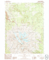
1986 Map of Mt. Shasta
USGS Topo · Published 1986About this map
Mt Shasta Natural Landmark dominates this mid-1980s provisional study, revealing a complex frozen landscape shaped by volcanic activity and glaciation within the Shasta National Forest. The map documents the intricate network of ice fields including the Hotlum Glacier, Whitney Glacier, and Wintun Glacier, which feed a radial system of drainage creeks such as Whitney Creek and Ash Creek. High-altitude features like Misery Hill and the Red Banks stand near the summit, while the western slopes feature the prominent volcanic cone of Shastina Lake. Researchers can observe the concentration of thermal activity at Sulphur Springs (Hot) near the Konwakiton Glacier. To the north, the terrain transitions into the Klamath National Forest via Military Pass, illustrating the transition from steep alpine ridges like Sargents Ridge to the more gradual forested northern gates.
Find a feature on this map
45 named features on this map. Tap any name to fly to it.
Don’t see what you’re looking for? This feature index may not catch every label — zoom into the map to look around manually.
Map Details
Editions of this 1986 Mt. Shasta Map
This is the sole edition of this map. No revisions or reprints were ever made.
Other maps of this area

1886 · Shasta
USGS Topo · 1:250,000

1894 · Shasta
USGS Topo · 1:250,000

1934 · Macdoel
USGS Topo · 1:96,000

1935 · Dunsmuir
USGS Topo · 1:125,000

1941 · Macdoel
USGS Topo · 1:125,000

1948 · Weed
USGS Topo · 1:250,000

1950 · Weed
USGS Topo · 1:250,000

1954 · The Whaleback
USGS Topo · 1:62,500

1954 · Shasta
USGS Topo · 1:62,500

1954 · Weed
USGS Topo · 1:62,500