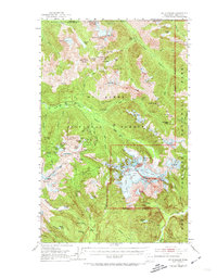
1953 Map of Mt Shuksan
USGS Topo · Published 1974About this map
Mt Baker National Forest and the High Cascades dominate this mid-century survey, which details a landscape defined by glacial peaks and early wilderness access points. Near the base of the massif, Mt Baker Lodge and Galena Camp served as primary hubs for hikers and climbers, while the high country was still actively being explored for mineral wealth. The map records several notable industrial operations, including the Lone Jack Mine, Red Mountain Mine, and Silvertip Mine, which reflect the region's mining history before much of the area was designated as part of the North Cascades National Park. The intricate drainage networks of Silesia Creek and the North Fork Nooksack River are captured alongside high-altitude landmarks like Austin Pass and the Silesia Creek Shelter, documenting the infrastructure of 1950s recreation and extraction.
Find a feature on this map
109 named features on this map. Tap any name to fly to it.
Don’t see what you’re looking for? This feature index may not catch every label — zoom into the map to look around manually.
Map Details
Editions of this 1953 Mt Shuksan Map
4 editions found
Other maps of this area

1909 · Mt Baker
USGS Topo · 1:192,000

1915 · Mt. Baker
USGS Topo · 1:250,000

1952 · Lake Shannon
USGS Topo · 1:62,500

1952 · Mt. Baker
USGS Topo · 1:62,500

1952 · Hamilton
USGS Topo · 1:62,500

1953 · Mt Shuksan
USGS Topo · 1:62,500

1953 · Marblemount
USGS Topo · 1:62,500

1953 · Mt Challenger
USGS Topo · 1:62,500

1955 · Concrete
USGS Topo · 1:250,000

1958 · Concrete
USGS Topo · 1:250,000