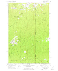
1973 Map of Mt Spokane
USGS Topo · Published 1977About this map
Mount Spokane State Park dominates this 1970s survey, capturing the recreation landscape at the boundary of Washington and Idaho. The summit of Mt Spokane is a center of activity, featuring the Vista House, a Radio Tower, and a Lookout Tower, alongside a network of Ski Lifts that serve areas like Bald Knob and Big Springs. This period shows the transition from rugged mountain terrain to a developed outdoor destination, with the park boundaries clearly defined against the Coeur D'Alene Nat Forest to the east.
Find a feature on this map
44 named features on this map. Tap any name to fly to it.
Don’t see what you’re looking for? This feature index may not catch every label — zoom into the map to look around manually.
Map Details
Editions of this 1973 Mt Spokane Map
2 editions found
Other maps of this area

1901 · Sandpoint
USGS Topo · 1:125,000

1901 · Spokane
USGS Topo · 1:125,000

1903 · Rathdrum
USGS Topo · 1:125,000

1911 · Priest Lake
USGS Topo · 1:250,000

1911 · Sandpoint
USGS Topo · 1:125,000

1913 · Priest Lake
USGS Topo · 1:250,000

1936 · Newport
USGS Topo · 1:96,000

1942 · Newport
USGS Topo · 1:125,000

1943 · Mt Spokane
USGS Topo · 1:62,500

1950 · Mt Spokane
USGS Topo · 1:62,500