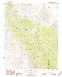
1984 Map of Mt. Stirling
USGS Topo · Published 1984About this map
Mt Stirling dominates the central landscape of this mid-1980s survey, marking a high point in the high-elevation terrain of the Spring Mountains. The map documents a rugged interior environment defined by its water sources, with numerous named points such as Jaybird Spring, Rock Spring, and Crystal Springs scattered across the slopes. The presence of the Stirling Mine in the northern reach suggests the area's history of mineral extraction, while the boundary between Nye Co and Clark Co runs through the eastern portion of the sheet.
Find a feature on this map
14 named features on this map. Tap any name to fly to it.
Don’t see what you’re looking for? This feature index may not catch every label — zoom into the map to look around manually.
Map Details
Editions of this 1984 Mt. Stirling Map
This is the sole edition of this map. No revisions or reprints were ever made.
Other maps of this area

1907 · Las Vegas
USGS Topo · 1:250,000

1908 · Furnace Creek
USGS Topo · 1:250,000

1908 · Las Vegas
USGS Topo · 1:250,000

1910 · Furnace Creek
USGS Topo · 1:250,000

1942 · Indian Spring
USGS Topo · 1:125,000

1942 · Skull Mountain
USGS Topo · 1:125,000

1948 · Death Valley
USGS Topo · 1:250,000

1952 · Specter Range
USGS Topo · 1:62,500

1952 · Mercury
USGS Topo · 1:62,500

1954 · Las Vegas
USGS Topo · 1:250,000