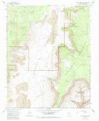
1967 Map of Mt. Trumbull SE
USGS Topo · Published 1984About this map
Grand Canyon National Monument dominates the southeastern portion of this 1960s-era survey, revealing the dramatic geological staircase between the Uinkaret Mountains and the Kanab Plateau. The landscape is defined by the central Toroweap Valley, a corridor flanked by massive Cliffs and punctuated by extensive Lava flows. Human presence in this isolated region of the Arizona Strip is recorded through remote outposts like Schmutz Ranch and Kent Ranch, alongside essential wilderness infrastructure including the Toroweap Ranger Station and the Toroweap Landing Strip. A network of Jeep Trails provides the primary means of navigation through the descent toward Toroweap Point and into the deep recesses of Big Cove. The map illustrates a period of federal land management where livestock ranching and national monument preservation coexisted on the rim of the Grand Canyon.
Find a feature on this map
23 named features on this map. Tap any name to fly to it.
Don’t see what you’re looking for? This feature index may not catch every label — zoom into the map to look around manually.
Map Details
Editions of this 1967 Mt. Trumbull SE Map
2 editions found
Other maps of this area

1886 · Mt. Trumbull
USGS Topo · 1:250,000

1886 · Kaibab
USGS Topo · 1:250,000

1892 · Mt. Trumbull
USGS Topo · 1:250,000

1953 · Grand Canyon
USGS Topo · 1:250,000

1957 · Grand Canyon
USGS Topo · 1:250,000

1958 · Grand Canyon
USGS Topo · 1:250,000

1960 · Grand Canyon
USGS Topo · 1:250,000

1962 · Tuckup Canyon
USGS Topo · 1:62,500

1962 · National Canyon
USGS Topo · 1:62,500
1967 · Mt. Trumbull NE
USGS Topo · 1:24,000