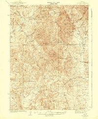
1942 Map of Mt. Velma
USGS Topo · Published 1942About this map
Humboldt National Forest encompasses the northern reaches of this high-desert landscape, where the Bruneau River and Beaver Creek drain the surrounding peaks. The map reveals a deeply established ranching culture during the 1930s, with dozens of family-named operations like the Colvin Ranch, Guerricabeitia Ranch, and multiple Prunty holdings scattered throughout the drainages. Resource extraction is anchored by the Mc Knights Placer Mine in the northeast, while small community hubs are evidenced by the Penrod Sch and Bryan Sch. Elevations shift dramatically from the high summit of Mt Velma (Haystack Mtn) down through rugged features like Blackburn Canyon and Cornwall Basin. The settlement pattern follows the water, with isolated dwellings such as Williams Cabin and Johnson Cabin marking the remote corners of this Elko County terrain.
Find a feature on this map
71 named features on this map. Tap any name to fly to it.
Don’t see what you’re looking for? This feature index may not catch every label — zoom into the map to look around manually.
Map Details
Editions of this 1942 Mt. Velma Map
2 editions found
Other maps of this area

1935 · Charleston
USGS Topo · 1:48,000

1936 · Mountain City
USGS Topo · 1:62,500

1936 · Rowland
USGS Topo · 1:48,000

1940 · Rowland
USGS Topo · 1:62,500

1940 · Mountain City
USGS Topo · 1:62,500

1942 · Mt. Velma
USGS Topo · 1:62,500

1943 · Jarbidge
USGS Topo · 1:62,500

1945 · Jarbidge
USGS Topo · 1:62,500

1955 · Wells
USGS Topo · 1:250,000

1956 · Wild Horse
USGS Topo · 1:62,500