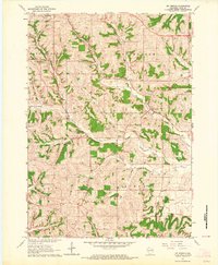
1962 Map of Mt. Vernon
USGS Topo · Published 1964About this map
The West Branch Sugar River and its tributaries carve a complex drainage pattern through the unglaciated uplands of Dane County. In the early 1960s, the village of Mt Horeb serves as the primary northern hub, while the smaller settlements of Mt Vernon and Primrose anchor the rural landscape to the south. This area is characterized by a high density of local landmarks and civic infrastructure, from the Mt Vernon Landing Strip and Townhall to numerous active quarries scattered throughout the ridges. Genealogists will find significant value in the distribution of rural burial sites, including East Primrose Cem, West Primrose Cem, and Oak Hill Cem. The educational landscape of the era is captured through surviving landmarks like Britt Valley Sch and Dixon Sch, while natural features such as Donald Rock and Devils Chimney reflect the unique geology of the Britt Valley region.
Find a feature on this map
31 named features on this map. Tap any name to fly to it.
Don’t see what you’re looking for? This feature index may not catch every label — zoom into the map to look around manually.
Map Details
Editions of this 1962 Mt. Vernon Map
2 editions found
Other maps of this area

1907 · Cross Plains
USGS Topo · 1:62,500

1909 · Cross Plains
USGS Topo · 1:62,500

1920 · Blue Mounds
USGS Topo · 1:62,500

1922 · Blue Mounds
USGS Topo · 1:62,500

1923 · Blanchardville
USGS Topo · 1:62,500

1923 · New Glarus
USGS Topo · 1:62,500

1954 · Rockford
USGS Topo · 1:250,000

1955 · Rockford
USGS Topo · 1:250,000

1957 · Madison
USGS Topo · 1:250,000

1958 · Rockford
USGS Topo · 1:250,000