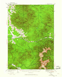
1935 Map of Mt. Washington
USGS Topo · Published 1960About this map
Mount Washington Cog R R climbs the steep eastern slopes of the Presidential Range, terminating at the Summit House near the Lakes of the Clouds. This mid-1930s survey records a landscape defined by its alpine trails and early tourism infrastructure, including the Base Station and various mountaineering shelters like the AMC Hut. To the north and west, the terrain transitions into the agricultural and timbered valleys of Jefferson and Randolph, where small settlements and schoolhouses like the Mt Cabot Sch and Gore Sch served the local community.
Find a feature on this map
181 named features on this map. Tap any name to fly to it.
Don’t see what you’re looking for? This feature index may not catch every label — zoom into the map to look around manually.
Map Details
Editions of this 1935 Mt. Washington Map
4 editions found

Other maps of this area

1893 · Mt. Washington
USGS Topo · 1:62,500

1893 · Gorham
USGS Topo · 1:62,500

1894 · North Conway
USGS Topo · 1:62,500

1895 · Crawford Notch
USGS Topo · 1:62,500

1896 · Mt. Washington
USGS Topo · 1:62,500

1896 · Crawford Notch
USGS Topo · 1:62,500

1896 · North Conway
USGS Topo · 1:62,500

1896 · Gorham
USGS Topo · 1:62,500

1900 · Whitefield
USGS Topo · 1:62,500

1920 · Guildhall
USGS Topo · 1:62,500