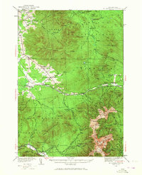
1935 Map of Mt. Washington
USGS Topo · Published 1967About this map
The White Mountain National Forest dominates this mid-1930s landscape, where rugged peaks are accessed by a dense network of historic hiking paths and early mountain infrastructure. The Mount Washington Cog RR climbs toward the summit, while the valley floor supports the Boston and Maine Railroad connecting local stations like Jefferson Sta and Randolph Sta. This era represents a peak for White Mountain tourism and forestry, evidenced by the numerous mountain huts and ranger facilities such as the Israel River Ranger Station and the Lonesome Ridge Fire Tower. Small mountain communities and seasonal retreats like Bretton Woods, Jefferson Highlands, and Fabyan dot the lowlands, while rural life is marked by the Mt Cabot Sch and Gore Sch. Numerous drainage systems, including the Ammonoosuc River and Israel River, carve through the massive ranges defined by the Pilot Range and Pliny Range.
Find a feature on this map
173 named features on this map. Tap any name to fly to it.
Don’t see what you’re looking for? This feature index may not catch every label — zoom into the map to look around manually.
Map Details
Editions of this 1935 Mt. Washington Map
4 editions found

Other maps of this area

1893 · Mt. Washington
USGS Topo · 1:62,500

1893 · Gorham
USGS Topo · 1:62,500

1894 · North Conway
USGS Topo · 1:62,500

1895 · Crawford Notch
USGS Topo · 1:62,500

1896 · Mt. Washington
USGS Topo · 1:62,500

1896 · Crawford Notch
USGS Topo · 1:62,500

1896 · North Conway
USGS Topo · 1:62,500

1896 · Gorham
USGS Topo · 1:62,500

1900 · Whitefield
USGS Topo · 1:62,500

1920 · Guildhall
USGS Topo · 1:62,500