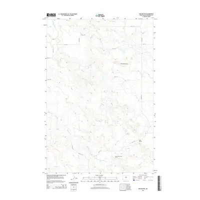
2014 Map of Mud Buttes
USGS Topo · Published 2014About this map
Mud Buttes and Rattlesnake Buttes anchor this southwestern North Dakota landscape, where the high plains break toward the Little Missouri River valley. The map reveals a strictly organized grid of rural roads, including 166th Ave SW and 97th St SW, which weave between intermittent watercourses like Skull Cr and Sevenmile Cr. A significant local landmark, the Vernon Miller Private Airport, indicates the continued importance of private aviation in navigating this expansive ranching country. The drainage patterns of Horse Cr and Fivemile Cr provide a clear view of the erosion and topography typical of the badlands region, illustrating the intricate relationship between the land's relief and the sparse human infrastructure of the early 21st century.
Find a feature on this map
19 named features on this map. Tap any name to fly to it.
Don’t see what you’re looking for? This feature index may not catch every label — zoom into the map to look around manually.
Map Details
Editions of this 2014 Mud Buttes Map
This is the sole edition of this map. No revisions or reprints were ever made.
Other maps of this area

1935 · Buffalo
USGS Topo · 1:125,000

1953 · Dickinson
USGS Topo · 1:250,000

1954 · Lemmon
USGS Topo · 1:250,000

1957 · Dickinson
USGS Topo · 1:250,000

1957 · Lemmon
USGS Topo · 1:250,000

1969 · Table Mountain
USGS Topo · 1:24,000

1973 · Kid Creek
USGS Topo · 1:24,000

1973 · Camel Butte
USGS Topo · 1:24,000

1973 · Cedar Hills
USGS Topo · 1:24,000
1973 · Mud Buttes
USGS Topo · 1:24,000